About DAKIS
DAKIS – Digital Agricultural Knowledge and Information System
Loss of biodiversity, scarcity of resources, climate change and an increasing demand for food are leading to conflicting goals in land management around the world. The harmonization of these conflicting goals through an optimally balanced provision of ecosystem services (ES) represents a major challenge for the agricultural systems of the future. The optimal provision of ES is the focus of the DAKIS project and should be made possible by a new digital decision support system as well as small-scale and diversified land management (DAKIS vision).
The DAKIS project has the following goals:
- Integrating ecosystem services, biodiversity and resource efficiency into the decision-making process of farmers.
- Documentation, forecasting and control of site-specific effects of agricultural activities in real time for the first time.
- Optimization of cultivation systems for ecosystem services, biodiversity and resource efficiency.
- Development of new orientation goals in operational planning and support of complex decisions.
- Creation of new communication channels for cooperation between farmers, consumers and society.
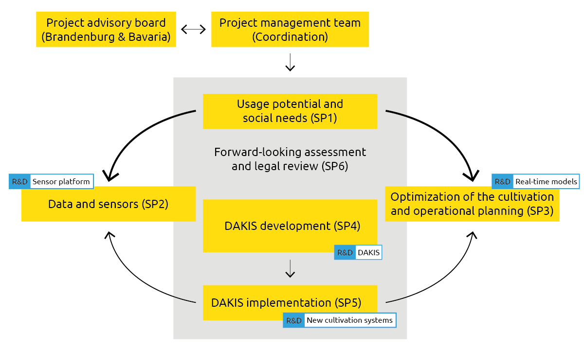
DAKIS wants to use the advancing digitization to integrate ecosystem services (ES) and biodiversity into modern planning, production and marketing processes. The joint project is divided into six sub-projects (SP).
In one pilot region each in Brandenburg and Bavaria the natural potentials and societal needs for ES and biodiversity are analyzed (SP1 – site-related potential uses and societal needs). By means of GIS analyses, small-scale site characterization is carried out (assessment of the current state) and, based on this, optimized landscape patterns for the provision of ES and biodiversity are developed. In parallel, society’s need for ES and biodiversity in the pilot regions is analyzed.
DAKIS project structure with sub-projects
In the subproject “Data and sensors – real-time monitoring of agro-ecosystems” (SP2), sensors and models are developed that enable the recording and simulation of ES in real-time. The aim of SP2 is a continuous recording and description of the landscape of the pilot regions as well as the experimental fields in their entire structure, paying particular attention to their small-scale heterogeneity. A wireless sensor network is being developed to record and implement site-specific requirements on a small-scale in real-time.
The data collected in SP2 are required for the “Optimization of the cultivation and operational planning” which takes place in SP3. The aim of this sub-project is the identification of the optimal operational production adapted to the location, including the remuneration of ES. The farming operations of the site are modeled for this purpose and optimal solutions and scenarios are found between the contrasting priorities of economics, ES and the technical measurement feasibility.
In SP 5 ( DAKIS implementation ) the differentiated provision of ES, biodiversity and biogenic products is tested in practice. Through the use of smart farming technologies, innovative cultivation methods are being tested and developed that make it possible to realize different production goals within a usable area, on a small-scale and sub-area-specific basis. The results obtained in SP5 thus also serve to validate DAKIS. The SP is subdivided into the following packages: arable land, grassland and robotics.
All activities of the sub-projects are covered by SP6 ( Forward-looking assessment and legal review ) accompanied and supported with foresight studies, sustainability and legal assessments. The law of digitization in particular is a highly complex matter that is currently developing in a wide variety of sub-areas. The area of responsibility ranges from clarifying legal semantics to legal forms of regulation. Data rights up to data ownership, big data, robotics, algorithm control, security and safety and legal handling of personal data, machine data, open data – geodata, environmental data, scientific data are analyzed. To this end, a legal design of the DAKIS system is being examined.
Regional project advisory boards will be established in the two pilot regions, which will actively participate in and further develop DAKIS. At the end of the project, there will be a prototype of the DAKIS system, which will propose options for action for the two pilot regions.